

.jpg)
.jpg)
.jpg)
.jpg)
.jpg)
.jpg)
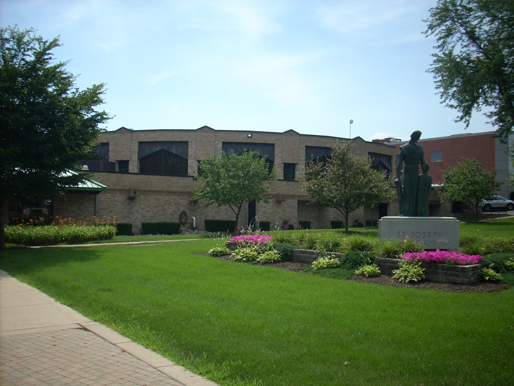
Building name: Central Park
Ground Floor Use: Park
Upper Floor Use: N/A
Current Occupant: Sunrise Rotary Park
Zoning: Sunrise Rotary Park
Number of Stories: N/A
Property Index Number: N/A
Within Local District?: No
Local Dist Contrib/Non-Contrib?: C
Local Landmark?: No
Year: No
Local Landmark Eligible?: No
Criteria: No
NR District Contrib/Non-Contrib: C
Within District?: No
NR Landmark?: No
Year: No
NR Eligible?: No
Criteria: No
Alternate Address?: No
Category: site
Condition: Good
Integrity: Good
Current Use: Landscape - park
Historic Use: Landscape - park
Secondary Structure: Landscape - park
NR Second: Landscape - park
Architectural Classification: Park
Details: Park
Other Year: 1988, 2000 (c)
Date source: Illinois Digital Archives/plaque/surveyor
Wall Material (Current): Illinois Digital Archives/plaque/surveyor
Wall Material 2 (Current): Illinois Digital Archives/plaque/surveyor
Plan: Illinois Digital Archives/plaque/surveyor
No of Stories: Illinois Digital Archives/plaque/surveyor
Roof Type: Illinois Digital Archives/plaque/surveyor
Roof Material: Illinois Digital Archives/plaque/surveyor
Foundation: Illinois Digital Archives/plaque/surveyor
Porch: Illinois Digital Archives/plaque/surveyor
Window Material: Illinois Digital Archives/plaque/surveyor
Window Material 2: Illinois Digital Archives/plaque/surveyor
Window Type: Illinois Digital Archives/plaque/surveyor
Window Configuration: Illinois Digital Archives/plaque/surveyor
Significance: Illinois Digital Archives/plaque/surveyor
Historic Features: Overall area of park is the same as 1893
Alterations: Gazebo (1988); playground at east end (c. 2000)
Old Address (city dir.year: Gazebo (1988); playground at east end (c. 2000)
Building Moved?: Gazebo (1988); playground at east end (c. 2000)
Moved From: Gazebo (1988); playground at east end (c. 2000)
Original Owner: Gazebo (1988); playground at east end (c. 2000)
Original Architect: Gazebo (1988); playground at east end (c. 2000)
Architect Source: Gazebo (1988); playground at east end (c. 2000)
Builder: Gazebo (1988); playground at east end (c. 2000)
Surveyor: LR
Surveyor Organization: Ramsey Historic Consultants
Survey Date: May-June 2016
Survey Area: Downtown Libertyville
Old Address: Downtown Libertyville
Date of Construction: Downtown Libertyville
Moving Permit #: Downtown Libertyville
Date Moved: Downtown Libertyville
Building Permit #: Downtown Libertyville
Date: Downtown Libertyville
Building Permit Description: Downtown Libertyville
Cost: Downtown Libertyville
Original Owner Occupied?: Downtown Libertyville
Exterior Alteration Permits: Downtown Libertyville
Other Permit Information: Downtown Libertyville
COA Info: Downtown Libertyville
Historic Info: From Illinois Digital Archives (info from Libertyville-Mundelein Historical Society and Cook Memorial Public Library): "A view of Central Park looking east from Milwaukee Avenue. The Catholic church and rectory can be seen through the trees in the background. According to local historian Dean Larson, the cannon was later moved to Cook Park. During World War II it was melted down. Central Park was officially set aside as a park when C. Frank Wright's subdivision became an addition to the village of Libertyville in 1893. Wright's addition was primarily a residential neighborhood surrounding the park, bordered by Broadway Street on the north, Park Avenue on the south, Second Street on the east and Milwaukee Avenue on the west."
Other Sources: Historic photographs of park at Illinois Digital Archives (in collection of Libertyville-Mundelein Historical Society and Cook Memorial Public Library): http://www.idaillinois.org/cdm/ref/collection/cookmemo11/id/37 http://www.idaillinois.org/cdm/ref/collection/cookmemo11/id/6270
Historic Info Compiler: LR
Volunteer: LR
 Contributing
 Non-contributing
.jpg)
.jpg)
.jpg)
.jpg)
.jpg)
.jpg)
.jpg)
.jpg)
.jpg)
.jpg)
.jpg)
.jpg)
.jpg)
.jpg)
.jpg)
.jpg)
.jpg)
.jpg)
.jpg)
.jpg)
.jpg)
.jpg)
.jpg)
.jpg)
.jpg)
.jpg)
.jpg)
.jpg)
.jpg)
.jpg)
.jpg)
.jpg)
.jpg)
.jpg)
.jpg)
.jpg)
.jpg)
.jpg)
.jpg)
.jpg)
.jpg)
.jpg)
.jpg)
.jpg)
.jpg)
.jpg)
.jpg)
.jpg)
.jpg)
.jpg)
.jpg)
.jpg)
.jpg)
.jpg)
.jpg)
.jpg)
.jpg)
.jpg)
.jpg)
.jpg)
.jpg)
.jpg)
.jpg)
.jpg)
.jpg)
.jpg)
.jpg)
.jpg)
.jpg)
.jpg)
.jpg)
.jpg)
.jpg)
.jpg)
.jpg)
.jpg)
.jpg)
.jpg)
.jpg)
.jpg)
.jpg)
.jpg)
.jpg)
.jpg)
.jpg)
.jpg)
.jpg)
.jpg)
.jpg)
.jpg)
.jpg)
.jpg)
.jpg)
.jpg)
.jpg)
.jpg)
.jpg)
.jpg)
.jpg)
.jpg)
.jpg)
.jpg)
.jpg)
.jpg)
.jpg)
.jpg)

.jpg)
.jpg)
.jpg)
.jpg)
.jpg)
.jpg)
.jpg)
.jpg)
.jpg)
.jpg)
.jpg)
.jpg)
.jpg)
.jpg)
.jpg)
.jpg)
.jpg)
.jpg)
.jpg)
.jpg)
.jpg)
.jpg)
.jpg)
.jpg)
.jpg)
.jpg)
.jpg)
.jpg)
.jpg)
.jpg)
.jpg)
.jpg)
.jpg)
.jpg)
.jpg)
.jpg)
.jpg)
.jpg)
.jpg)
.jpg)
.jpg)
.jpg)
.jpg)
.jpg)
.jpg)
.jpg)
.jpg)
.jpg)
(3).jpg)
(1).jpg)
.jpg)
.jpg)
.jpg)
.jpg)
.jpg)
.jpg)
.jpg)
.jpg)
.jpg)
.jpg)
.jpg)
.jpg)
.jpg)
.jpg)
.jpg)
.jpg)
.jpg)
.jpg)
.jpg)
.jpg)
.jpg)
.jpg)
.jpg)
.jpg)
.jpg)
.jpg)
.jpg)
.jpg)
.jpg)
.jpg)
.jpg)
.jpg)
.jpg)
.jpg)
.jpg)
.jpg)
.jpg)
.jpg)
.jpg)
.jpg)
.jpg)
.jpg)
.jpg)
.jpg)
.jpg)
.jpg)
.jpg)
.jpg)
.jpg)
.jpg)
.jpg)
.jpg)

.jpg)
.jpg)
.jpg)
.jpg)
.jpg)
.jpg)
.jpg)
.jpg)
.jpg)
.jpg)
.jpg)
.jpg)
.jpg)
.jpg)
.jpg)
.jpg)
.jpg)
.jpg)
.jpg)
.jpg)
.jpg)
.jpg)
.jpg)
.jpg)

.jpg)

.jpg)
.jpg)
.jpg)
.jpg)
.jpg)
.jpg)
.jpg)
.jpg)
.jpg)
.jpg)
.jpg)
.jpg)